
Mount Ida stands at almost 12,900 feet in Rocky Mountain National Park. The trailhead sits just west of the visitor’s center at the top of Trail Ridge Road, a 48-mile paved alpine road connecting the east and west entrances of the park.
There are plenty of mountains that stand taller than Ida in RMNP, and if you’re trying to identify Ida from a distance it may be a bit of a challenge initially because there’s nothing overly remarkable about the mountain…but the trail leading to the summit is fricking amazing! It’s a 9.5 mile out-and-back trail with the majority above tree line. There are wide-open views from the northwest to the southeast and all directions west.
The most challenging factor of the hike is the wind, unless you get caught in a fast developing thunderstorm out there. Then, that’s a whole different problem. At 11,000 – 12,500 feet, where the majority of this hike takes place, the wind can be brutal when it wants to have an attitude, and if you have any desire to get to the summit, you better make friends with the wind early or you’ll be arguing the entire way, and then eventually learn the wind always wins the argument…
I thought about Ida this morning as I wrote in my journal for a specific reason. As you can see below, the trail to Ida looks like this for the first 4 miles, easy to follow. But after you navigate along that ridge straight ahead in the picture, there’s a slight downhill for about half-a-mile before hitting just shy of the 4-mile mark and then it’s uphill to the summit.

(Somewhere around 3 miles from the Summit)
I talked a lot about the mountain… sorry, it was fun reliving the experience from my front porch at 4700 feet elevation this morning. But now let’s move on to the point of this post.
SUMMITTING
Like I said earlier, the final .4 – .5 miles is a bit of a challenge, but only because the trail is hard to find. I remember looking out ahead of me when we took this trail two summers ago. There were several different small parties scattered along the mountainside up ahead. I wondered which party was on track and which one got off track. Who should we follow and who should we avoid following…and should we follow any of them or are we all just making it up as we go?
We ended up taking a course that had some steep grades and it seemed like every 10-20 steps we had to stop and reassess if we were still on track and where our next steps would be taken. There was no clear trail; we were guessing our way to the top and progress wasn’t happening very fast. We could easily see the summit the entire time, but due to the rock features up there, taking a straight line was not an option…and there were times we would hit a spot that only presented options to go out of our way, so backtracking took place frequently.
Remembering this experience comes with some frustration because it was a descent length at 4.7 miles from trailhead to summit, the the elevation gain was about 2,400 feet… but that wind was a force to be reckoned with and fatigue was coming into play at this point. Although neither my daughter or I said it…we were both starting to have thoughts of, “Screw it…close enough!” But unless you’re dealing with potentially life-threatening circumstances, you just can’t get this close to the top and be okay turning around short of the goal… can you?
We’re about ready to jump off the trail and talk about how I bring this metaphor into everyday life… but one final part to share because this is a significant point of the post.
CAIRNS
I know, I know… Cairns are an issue out there on the trails. People build these rock markers to be helpful, but then when you have them all over the mountainside, they become confusing. One person takes one route so they build cairns to mark the trail. Another person takes a different route that seems good so they add cairns to mark their path. When the mountainside becomes littered with these cairns, those of us coming along afterwards have no idea which ones to follow.
However, on this day up there on Ida, we were wandering along trying to find our way to the summit. It would have been so helpful to look out ahead and see the next cairn to aim for. Then, after getting there, look for the next cairn… and on-and-on up the mountain to the summit.
Today, as I wrote in my morning pages, I thought about how helpful it would be to me if I could look out ahead and see the next “cairn” to aim for in my life. But right now, I see nothing but rock obstacles to navigate on my way to the “summit” I’m trying to reach. I wonder if I’m on track, or am I wandering off course; am I taking a long way to my destination? Is there a dead-end out ahead of me that will require I backtrack and choose another route?
These are all questions I have right now, and unfortunately, I don’t have the luxury of opening an AllTrails app and downloading the trail.
TRAILBLAZING… OR FOLLOWING THE WELL-TRAVELED PATH
I touched on this in a previous post “HELLO? ANYONE OUT HERE?” back in January, but I’m coming to the conclusion that following the herd is not the path a climber has any intention of taking. The path of the herd is well traveled and easy to follow. In fact, it may look a lot like I-25 at rush hour coming out of Denver… gridlock on the trail.
As I spoke of in the post I just referenced, there are a wide range of emotions a person can experience out in the wilderness on a trail not frequently traveled. Sure, there’s peace and quiet… most of us would love that quality. But as we travel further out, there is a sense of aloneness that may be enjoyable for a while, but then the imagination can play tricks on us. What if something happened to me out here? Would anyone know where to begin looking for me? If I do get lost, will Search & Rescue even know?
Perhaps I’m just putting all my cards on the table here, but doubts can become very loud in the quiet of wilderness… Questions of my skill set, my ability to adapt and be successful against obstacles that may be out ahead of me… obstacles I didn’t have the luxury to prepare for because there was no trails app to give warnings in the reviews…
If we want to stay safely in the herd, we simply need to know that at some point, that herd will be falling into line at the slaughterhouse. What that slaughterhouse looks like could be the place where dreams die and we fall into line in living the safe, secure, and “responsible” lifestyle…looking for some measure of relief from our weekends and vacations.
However, if we’re going to muster the courage to follow a dream, it may come with making our own trail through wilderness and trusting the compass within us when we feel lost.
I’m beginning to touch on some areas I will probably write about in a different post I’m calling “Compliance”, so I want to stay clear of going much further here. As a government employee, trudging forward, tracking my years of service and keeping an eye on what retiement could look like… I find more and more that I cannot become “comfortably numb” on this path. I’m stepping in a lot of shit as I follow the herd and my heart screams to get off this path ASAP.
It does not come without a fight though. I’m 60+ years old… do I really want to put the effort into making a new trail at my age? This is a real fight that many of us have to consider if we are going to step off the well-worn path and go a different way. There are most likely consequences (and benefits) with either decision… we simply must decide which consequences are easier to live with.
I’m stepping off the well-traveled path right now… and I’m looking for a cairn. There has to be someone who’s stepped off this path before me. I see no evidence yet… but I’m looking for a cairn… something to show me the next step to distancing myself from the herd.
As always, I hope to see you at the Summit.
Oh… I need to give you a taste of what it looks like up on top.
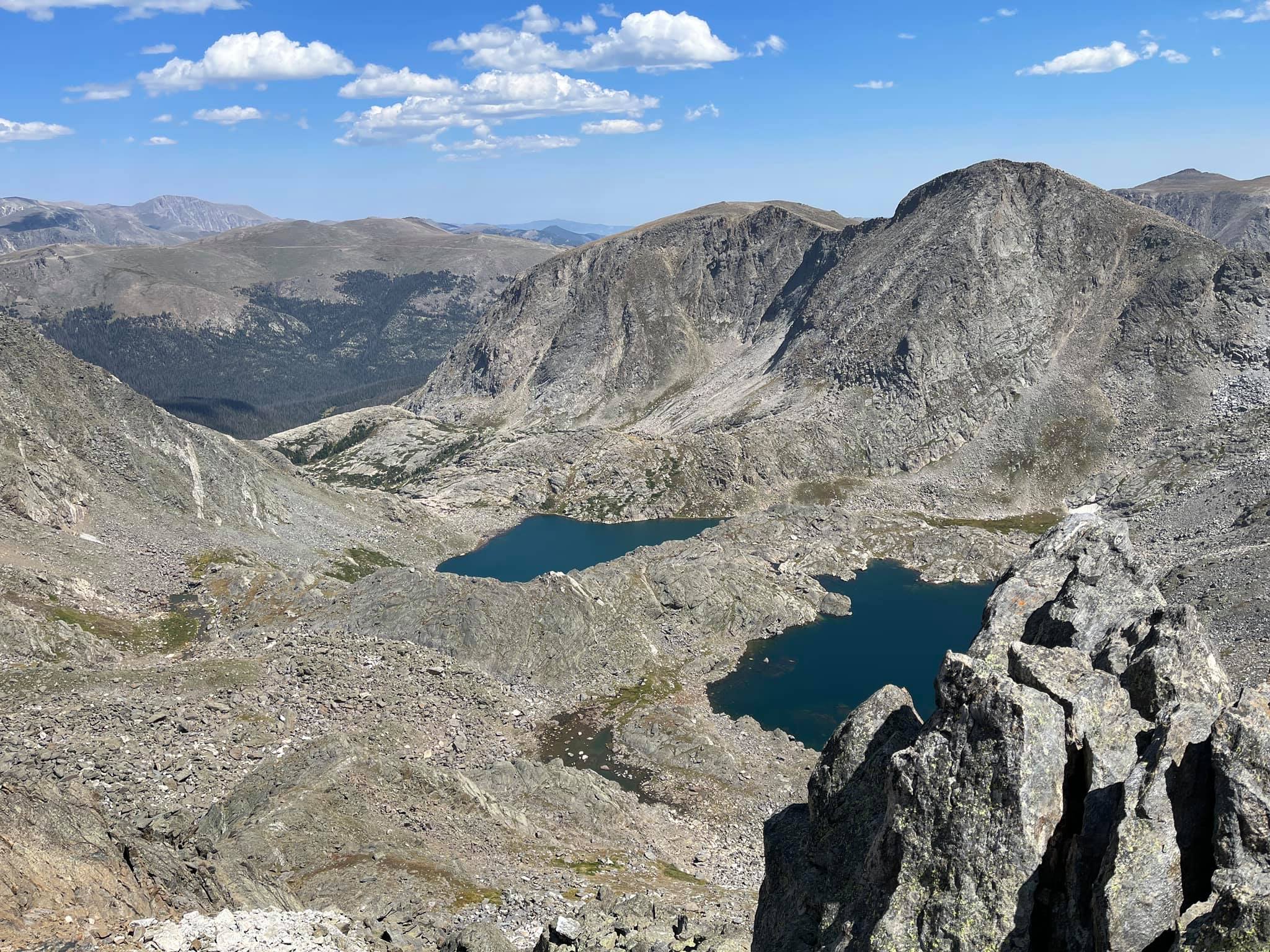
(Looking to the north and east toward Inkwell and Azure Lakes)

(Looking toward the South toward Granby)
See! Totally worth it right?